The Flood Nobody Saw
A geologist says a catastrophic flood once came down the Pine River. The evidence is sitting in gravel pits outside Bayfield, and nobody has spent the money to date it.
A rock that should not be there
On Shellhammer Ridge, east of Ignacio, an operator digging a gravel pit went down through fifteen to twenty feet of river gravel and hit a boulder sitting on the bedrock beneath it. Thirteen feet by twelve by seven — about forty-five tons.
That by itself is not remarkable. Southwest Colorado is full of big rocks. What is remarkable is what it is made of, and where its nearest relatives are: it is a slab of Vallecito Conglomerate, and the mountain front where that rock comes from is twenty-five miles up the valley, with the nearest outcrop further still.
Almost everything in this section comes from the fieldwork of one man, and we will get to him shortly. Keenan Lee, professor emeritus of geology at the Colorado School of Mines, spent years getting permission to walk gravel pits down the length of the Pine River, and what he found is a trail of these stranded boulders: eleven-footers lying loose on bedrock northeast of Bayfield, close to a hundred of them at a pit near La Boca, and more on a mesa above the San Juan River in New Mexico, seventy-two river miles below Vallecito Dam.
- 45 tons, largest measured
- 13 × 12 × 7 feet
- 25 miles from the mountain front
- 72 miles to the last of them
Rivers move rocks. Rivers do not usually move rocks like that at all, and they do not usually leave a trail of them seventy-two miles long. So the question this page is about is a simple one, and it has been asked twice, ninety-three years apart, with two different answers.
Calico rock, and why it can only be from here
The reason anyone can trace these boulders at all is that they are made of something unmistakable.
The Vallecito Conglomerate is around 1.7 billion years old. It was river gravel once — actual pebbles in an actual streambed — before it was buried, cooked and turned to stone. Locals call its brightest form calico rock, and once you have seen a piece you never mistake it: clasts of milky quartz, red jasper, and rusty bands of iron formation packed into hard gray stone.
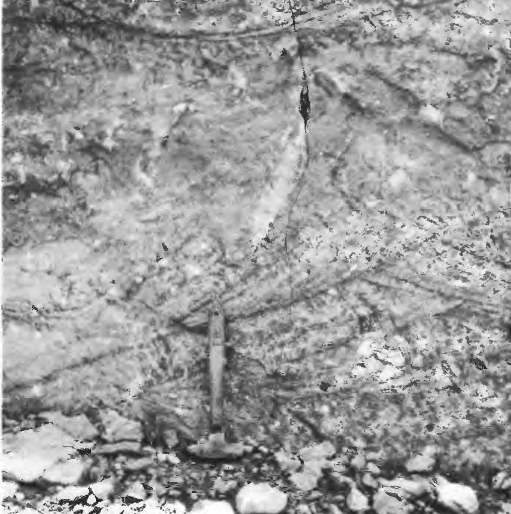
Two facts make this rock a fingerprint rather than just a pretty stone.
The first is that it is mapped only here. Barker surveyed the whole Needle Mountains for the USGS and concluded the formation “is found only in the southeastern part of the Needle Mountains… particularly along the Pine River.” It stands in the canyon walls of Vallecito Creek and the Pine a few miles above where they meet — in the canyons just above the lake, not beneath it.
The second is less obvious. The jasper and iron-formation pebbles inside it had to erode out of some older rock. Barker records that the rocks beneath the Vallecito Conglomerate are not exposed — so the terrain those pebbles came from cannot be pointed at on a map. They are orphans, and the conglomerate that holds them is the only place around here they turn up.
Find a piece of calico rock near Farmington and you know where it started. The only question left is how it got there.The tracer argument, in one sentence
One honest qualification, and Lee gets there before we do. A thin conglomerate at the base of the Uncompahgre Formation is, in Barker's description, lithologically similar to the Vallecito and may share its source rocks — and it does crop out in the Animas drainage. But it runs from about a foot and a half to twenty feet thick against the Vallecito's 2,400 feet and possibly more than 5,000, so it could not supply a boulder train. Lee makes the sharper point: those Uncompahgre beds carry only small pebbles, jasper more often black than red, and no iron formation at all. Saying the rock is found nowhere else overstates it. Saying nothing else around here could have produced these particular boulders does not.
The first people to write it down
In 1932 two geologists, Wallace Atwood and Kirtley Mather, published a Geological Survey monograph on the San Juan Mountains. They had already found the boulders. They photographed them, and the photograph survives.
Lee says in his acknowledgments that rereading Atwood and Mather is what set him off — it was their picture of a stranded boulder that struck him. So the route to this photograph is his, and we are following it.
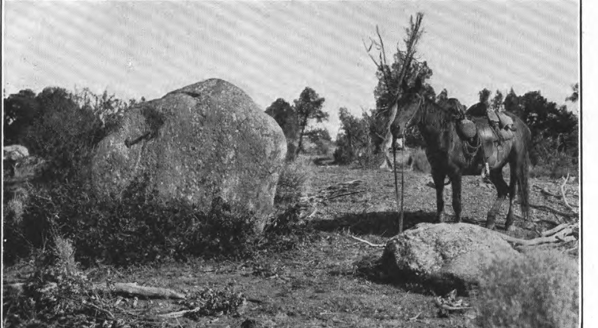
Every clause of that caption is doing work. At least 25 miles from their source. Not in the present stream courses. They had the anomaly in 1932 — they knew these rocks were far from home and sitting somewhere a river does not reach.
They also considered whether ordinary running water could have done it, and rejected it carefully:
“Although it would be unwise to assert that boulders 7 to 10 feet in diameter could not be washed over low gradients for distances of 25 or 30 miles, such a contingency is certainly very unlikely.”
Atwood and Mather, 1932, p. 106–107
Their answer was a glacier. Ice can carry anything, and it does not care about gradient. They drew it, too.
The valley with a glacier in it
Folded into the back of that 1932 report is a hand-colored map of the San Juan Mountains as Atwood and Mather believed the region looked at the height of the last Ice Age, with the glaciers restored to full size. Our valley is on it.
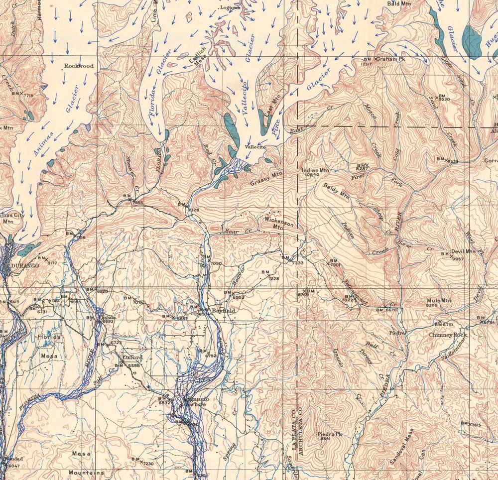
Where the lake is now, there was a glacier — two of them, in fact, one coming down Vallecito Creek and one down the Pine, merging near where the dam stands today. The moraines they left are still there. You drive over one on the way to the lake.
But look at where the ice stops, and then look at Ignacio. The boulders in that photograph are about twenty-five miles beyond the end of the ice.
A different explanation, published in 2025
In November 2025 the Colorado Geological Survey published Lee's argument that the boulders were not carried by ice at all. They were carried by water — a single catastrophic flood, running the length of the Pine River from Vallecito to the San Juan.
His objection to the glacier is direct, and it is the kind of argument a reader can check. Three published quadrangle maps cover the ground between the moraines and Ignacio — Carroll and others in 1998, Gonzales and others in 2004 and 2008 — and Lee points out that none of them shows any glacial deposit below the end moraines at Vallecito Reservoir. The ice stopped where the 1932 map says it stopped. The rocks kept going.
What he found downstream is worth stating precisely, because it is less than the headline suggests. In Colorado he found no flood deposits at all — only stranded boulders lying on bedrock, and boulders sitting at the base of later, ordinary river gravels that were laid down around them. Actual flood gravel appears only across the New Mexico line.
- Beaver Creek, near Bayfield — fifteen feet of boulder gravel on a terrace 100 to 150 feet above the river, under five to ten feet of windblown silt.
- Shellhammer Ridge, east of Ignacio — the forty-five-ton boulder, and hundreds more pulled from the same pits, all of them at the bottom of the deposit.
- La Boca, at the state line — close to a hundred boulders at the base of the gravel, where the river leaves open country and drops into a canyon a thousand feet deep.
- Martinez Mesa, New Mexico — the last of the flood gravel, about 750 feet above the San Juan River and some 45 miles below Vallecito Dam. Beyond it, only scattered boulders, for another twenty-seven miles.
There is a detail at the far end of that list which Lee notes almost in passing and which stays with you. The gravel capping Martinez Mesa is the last surviving deposit of the whole event. On top of it, the State of New Mexico has paved a runway: Navajo Lake Airport, just under a mile of asphalt laid over the last of it, taking a couple of hundred flights a year from pilots who have no reason to know.
Lee's proposed mechanism is a glacial outburst — water ponded behind a dam of ice or moraine in the upper valley, released at once. He is candid that he cannot prove it, and that a landslide dam “cannot be ruled out, but no evidence remains of a candidate landslide.”
Older than our species
There is no date for the flood. Lee says so himself, in the plainest language available: “the time of the flood is likewise unknown, because no flood deposits have been dated.”
What exists instead is a floor, and it is worth following the chain because the chain is the argument. Over on the Animas, a layer of volcanic ash from the Yellowstone caldera — the Lava Creek B ash, dated to 639,000 years ago — caps a gravel formation called the Florida Gravel. On the Pine, at Shellhammer Ridge, it is the Florida Gravel that buries these boulders. If the two are the same gravel, then the boulders were already lying there before the ash fell — and because the gravel was laid down around boulders that were already stranded, Lee argues they must be considerably older still. The correlation between the two drainages is his, and it is the step the whole floor rests on.
Treat 639,000 as a minimum, not a date. Lee argues for early Pleistocene, which would put it past three quarters of a million years and possibly well beyond a million and a half. Even at the minimum, it does something to the scale of the thing:
The flood predates our species by at least three hundred thousand years. It happened at minimum six hundred thousand years before any human being stood in North America. No Ute saw it. No Ancestral Puebloan saw it. Nothing that could be called a person had yet evolved.
Take that minimum and compress it into a single calendar year beginning on January 1 — remembering the real figure is probably two or three times longer, which only makes the point harder. The first people reach the Americas around December 18. Clovis hunters arrive in Colorado on the 24th. The great house at Chimney Rock goes up on the morning of December 31. The Brunot Agreement is signed at 9:54 that night. Vallecito Dam is dedicated at ten minutes to eleven.
And for scale at the other end: the largest flood in this region's recorded history was the storm of October 4–6, 1911, which put the Animas at Durango at roughly 25,000 cubic feet per second and destroyed bridges, rail and farms across the Four Corners. That is the ceiling of human memory here. It did not move forty-five-ton rocks to New Mexico.
What would settle it
Any reader who knows the history of this subject will think of J Harlen Bretz — the geologist who argued in the 1920s that the scablands of eastern Washington were carved by a catastrophic flood, was ridiculed for decades, and was eventually proved right. Lee himself mentions Bretz only once, and not about his own work: in the acknowledgments, explaining why Atwood and Mather reached for a glacier in 1932, before catastrophic floods were something a geologist could propose in polite company.
But the comparison is the one every reader will make, so it is worth following all the way through — because it cuts both ways.
Bretz did not win on boulders. He won in 1940, when Joseph Pardee showed that glacial Lake Missoula — some five hundred cubic miles of water behind a known ice dam, which Pardee had mapped thirty years earlier — had drained catastrophically. He won again in 1956, when giant current ripples were mapped from the air in the scablands themselves: thirty feet high, three hundred feet apart. The boulders were the puzzle. The lake and the ripples were the proof.
The Vallecito case has the boulders. It does not yet have a mapped lake, it does not have flood bedforms, and it does not have a date. The last of those is not exotic — it is a standard laboratory technique called cosmogenic burial dating, applied to a gravel-capped terrace.
Fort Lewis College, thirty miles from these deposits, has a geologist on faculty who does this kind of dating. A student, a summer and a few thousand dollars in laboratory analyses could put a number on Martinez Mesa and close a question that has been open since 1932 — though Lee reports that no exposure of the flood gravel has been found on the mesa, so somebody would have to dig one first.
Bretz did not win on boulders. He won on a lake and a set of ripples.What is still missing here
What this page is not telling you
This is an unusually easy story to oversell. What follows is not a takedown — this is a careful field geologist putting his own observations on the permanent record, after years of negotiating access one gravel pit at a time along seventy-two miles of river, largely on his own time. It is simply what the work does and does not establish.
- It is a proposal, not a finding. The paper appeared in the Colorado Geological Survey's Research Notes series, which states on its own cover that such submissions “have not been subject to the typical Colorado Geological Survey review process,” though they are screened for relevance and basic technical quality. It is not peer-reviewed and it is not the agency's position. Mary Gillam of the Survey did review the work in progress and, by Lee's account, talked him out of at least one interpretation.
- Lee calls his own Colorado evidence thin. In his words the route through Colorado is “poorly constrained” and the evidence there “is sparse… and allows room for conjecture.” The firm part of the case is all in New Mexico.
- There is no discharge figure, and you will not find one here. The paper contains no hydraulic modeling, no high-water marks, no scour features, no cross-sections. It is a boulder-only case. Any number in cubic feet per second attached to this flood would be invented.
- The 350 feet is not a flood depth. Boulders sit up to 350 feet above the modern river because the river has been cutting down ever since — by Lee's own reckoning about a thousand feet since the flood. It is not how deep the water was.
- Some of it is remembered rather than logged. The fact that the Shellhammer boulders lie at the base of the gravel — which the whole minimum-age argument depends on — comes from a pit operator's recollection to Lee in 2011. The hundred boulders at La Boca come from a pit supervisor's written account in 2013. Lee cites both honestly. Neither is a measured exposure.
- Other geologists have read this ground differently. Atwood and Mather called the deposit interglacial alluvium and the boulders glacial erratics; Richmond in 1965 called the deposit outwash; Lee calls the boulders flood boulders. Three readings, no new dates. And two Colorado Geological Survey publications now disagree about the age of the same moraine below Vallecito Dam — a 1998 quadrangle map calls it Bull Lake in age, considerably younger than this paper does.
- The “regional pattern” is mostly one man's. Lee places this flood among a set of similar San Juan outburst floods. Of the seven papers he cites for that pattern, four are his own — three of them Research Notes published alongside this one in the same non-reviewed series. Three are other people's work. One person noticing the same thing in five valleys is how this sort of case usually starts, but it is not independent confirmation.
- We are not repeating the island claim. You may read that the small island in Vallecito Reservoir is the exposed crest of a glacial moraine. That appears in a figure caption in this paper and, as far as we can find, nowhere else — no survey, no bathymetry, no map. It may well be true. It is not yet documented, so we are leaving it alone.
- The longest gap in the record is one nobody has walked. A long stretch of the route crosses the Southern Ute Indian Reservation, where Lee states access is restricted. He needed permission from every landowner along seventy-two miles and thanks five aggregate companies and numerous Bayfield-area landowners for it; the Tribe is one landowner among many, and the one with by far the longest relationship to this river. Whatever that stretch holds has not been examined by an outside geologist.
- We could not confirm the 1911 flood on the Pine. That storm is well documented on the Animas, the San Juan and the Piedra. The Pine almost certainly flooded too, but we could not find it in a source, and inference is not record. Durango papers from that month exist on microfilm and would settle it.
Where you can actually touch it
The rock at the center of all this is a short walk from the campground.
The Vallecito Creek Trail climbs into a canyon whose walls are Vallecito Conglomerate, and the photograph further up this page was taken about half a mile north of Vallecito Campground. Wet the rock and the colors jump — the jasper goes properly red.
Check conditions before you go. Middle Bridge, up the trail north of Second Creek, was washed out completely in the October 2025 flood and has not been replaced. The lower canyon is what matters for the rock, but the trail beyond is not what it was.
On picking rocks up: don't, and the rules are stricter than most visitors assume. In the Weminuche Wilderness, collecting is prohibited outright. Elsewhere on the San Juan National Forest, the Forest asks for a permit even for personal-use collecting of common stone, and federal regulation prohibits removing or damaging natural features anywhere on the forest. Chipping a sample off a cliff face is not a gray area. Call the Columbine Ranger District if you want to know what is actually allowed where you are standing. Photographs are free and unlimited.
Two more things worth knowing. The cliffs nearest the trailer park at the south end are private property — admire them from the road. And if you find yourself in Durango with an eye out for it, there is a garden wall at 3rd Avenue and 8th Street built of this stone, legal to photograph from the sidewalk.
The flood boulders themselves are a harder ask. Every locality in the paper is an active gravel pit, private land, or the reservation. There is no public overlook, no sign, and no marked stone. Nowhere in this valley, or in Durango, is there an interpretive panel about any of this.
Which leaves an opening. If you have a piece of calico rock in your yard, or your family pulled one out of a field, we would like to know where it came from. A map of where these things actually turn up is the sort of thing a community can build and nobody has funded.
Tell us where yours came fromSources & notes
The flood hypothesis, the field localities, the boulder measurements, the seventy-two-mile trace and the Lava Creek B age argument are all from Keenan Lee, The Vallecito flood — a catastrophic flood on Los Pinos River, southern San Juan Mountains, Colorado and New Mexico: Colorado Geological Survey Research Notes 1, 2025. The 1932 material — the photograph, the ice-age map, and the quoted reasoning about boulder transport — is from Wallace W. Atwood and Kirtley F. Mather, Physiography and Quaternary Geology of the San Juan Mountains, Colorado: USGS Professional Paper 166. The description and mapped extent of the Vallecito Conglomerate, and the outcrop photograph, are from Fred Barker, Precambrian Geology of the Needle Mountains, Southwestern Colorado: USGS Professional Paper 644-A, 1969. The moraine mapping that disagrees on age is Carroll, Kirkham and Wilson, Colorado Geological Survey Open-File Report 98-2. The 1.70-billion-year age comes from Karlstrom, Gonzales, Heizler and Zinnser, New Mexico Geological Society Guidebook 68 (2017), and brackets the rock group containing the conglomerate rather than the conglomerate itself, which has never been directly dated. Human chronology is from the U.S. Geological Survey's White Sands footprint study, the Colorado Council of Professional Archaeologists' Southern Colorado River Basin context, and the Southern Ute Indian Tribe. The 1911 flood account is from KSUT's reporting on the Four Corners flood. The Bretz chronology is from Pardee's 1940 and 1942 papers on glacial Lake Missoula and from Bretz, Smith and Neff, Geological Society of America Bulletin, 1956.
On the images. All three photographs and maps on this page are works of the U.S. Geological Survey and are in the public domain; they are reproduced as crops of the original plates, resized but otherwise unaltered. None of the figures from the 2025 Colorado Geological Survey report are reproduced here, because that publication carries a copyright notice and no stated reuse terms. Two notes on the 1932 plate: its title calls the stones “Boulders of Vallecito conglomerate,” but they are boulders derived from the formation and carried out to the Ignacio plain — they are not an outcrop of it, and the outcrop is the Barker photograph. And its caption gives the larger ones as “at least 12 feet long,” where Atwood and Mather's text describes boulders “as much as 10 feet in diameter”; both are quoted as printed.
On certainty. Where this page says a thing is proposed, argued or interpreted, that is deliberate. Where it says a thing is mapped or measured, that is deliberate too. A geologist reading this should not find a claim here that outruns its source. If you think we have got one wrong, we would rather hear it than not. How to submit a correction.
Related: The valley under the lake · The October 2025 flood · Vallecito Creek Trail · 85 years of lake levels