The Valley Under the Lake
Before Vallecito Lake there was a ranching valley with a wagon road and a post office that opened twice. This is what the record shows — and what it doesn’t.
Before it was a lake
The water you are looking at is 85 years old. The valley under it is a great deal older, and for most of its recorded history it belonged to the Ute people.
An 1868 treaty set aside the western half of Colorado as Ute land — a date that still matters, because it became the priority date for water rights on the Pine River, senior to everyone. Five years later, at the Los Pinos Agency on September 13, 1873, the Brunot Agreement took roughly 3.7 million acres of the San Juan Mountains back out of Ute hands. Congress approved it on April 24, 1874.
The Southern Ute Indian Tribe does not describe that as a sale. Its own published history says the Utes believed they were giving up mineral land only, expected some four million acres of non-mining country to remain theirs, and instead “ended up forcibly relinquishing the lands” — remembered, in the Tribe's words, “as the agreement when their land was fraudulently taken away.”
That boundary is not an abstraction here. Both surviving pre-dam topographic maps of this country carry the line printed across them in the map collar: SOUTH BOUNDARY CEDED UTE LAND. It is the line that opened the upper Pine to homesteaders, and you can see it on the same sheets that show the valley before the water.
Sources: Southern Ute Indian Tribe; Colorado Encyclopedia; Bureau of Reclamation, The Pine River Project; USGS Ignacio quadrangle, 1908 and 1924 editions.
The people the record actually names
Settlement came early and stayed thin. The first known non-Indigenous settler in the Pine River valley was John Taylor, a former slave who served in the Union Army, who arrived around 1871–73 — before the cession had fully taken legal effect. Reclamation's own history puts it plainly: “The earliest record of white settlement in the Pine River Valley dates to 1876, and the first ditches in the area were constructed in 1877.” Homesteading families named in the county record from 1877 include Pargin, Wommer, Bates and Patton. By 1899, 375 allotments totalling 72,970 acres had been awarded along the Pine.
Most of the family names attached to the drowned ground circulate locally without citations, so we won't print them as fact. But there is one clean primary source, and it is worth reading for what it is — a routine land notice in a Durango paper that happens to preserve eight neighbours by name.
“Candace Root, of Vallecito, county of La Plata, state of Colorado, has this day filed in this office her sworn statement No. 744”
Durango Semi-Weekly Herald, August 27, 1903, page 3
Her witnesses were Roy Crandall, George Melville, Charles C. Graham and John T. Graham, all “of Vallecito, Colorado.” A second notice on the same page covers Schuyler C. Whitney of Vallecito, witnessed by George W. Melville and John N. Root. Two Grahams, and Graham Creek still runs into the east side of the lake. Charles C. Graham is remembered locally as the homesteader of what became Teelawuket Ranch, which still stands and is listed on La Plata County's own historic driving tour.
Land notices via the Library of Congress: August 27, 1903 (the same notice also ran August 13 and August 20). Settlement dates: La Plata County, Pioneers, Prospectors and Trout (2010); Bureau of Reclamation.
“Colorado's most valuable stream”
In the summer of 1906 the Durango paper ran an appreciation of the Pine that reads very differently now. It boasted that the river carried as much water every minute as the Animas, called the surrounding country a valley “50 miles long and 26 miles wide,” and then — in a line nobody could have known would age the way it did — made a promise about how much farmland the river could serve.
“all can be covered with water without building the first storage reservoir.”Durango Semi-Weekly Herald, July 26, 1906
Thirty-two years later the government began building the reservoir. The same paper's promotional coverage of the 1909 Ute land opening sold this valley as orchard country, quoting a rancher named Jo W. Turner: “My orchard, which is in this immediate vicinity, netted me last year $750 per acre.” Up in the headwaters, a private hatchery at the Emerald Lakes was shipping trout out by the million on pack horses — 1,005,000 fry in 1900 alone — a story we tell on the fishing page.
July 26, 1906, page 4; May 27, 1909, page 3; Colorado State Game and Fish Commissioner, biennial report 1899/1900, pp. 41–42.
A post office that opened twice
There was never a town called Vallecito. There was, however, a post office — and the pattern of its opening and closing is the closest thing we have to a census of the valley.
- Pine River · 1878–1895
Served the settlement on the east bank where the Pagosa Springs–Animas City toll road crossed the river, about four miles north of present-day Bayfield. A store, hotel, stage station, flour mill and roughly 100 residents. When Bayfield was platted in 1898 the office closed and moved there. This settlement was below the dam site — it is not under the lake.
- Los Pinos · 1889–1899
Ten years, then gone.
- Vallecito · 1901–1916
Fifteen years of mail for the valley's ranches, closing during the First World War.
- Vallecito · 1939–1942
Then nothing for twenty-three years — until a second Vallecito post office opened in 1939, the year after construction started, and closed in 1942, the year the dam went operational. It was a post office for the dam builders, not for the valley.
Jim Forte Postal History, La Plata County, Colorado. Note that some sources compress these into a single office “1901 to 1942,” which erases the twenty-three-year gap.
The valley, drawn before the water
Two government maps of this valley survive from before the dam, and they are the same map twice: the Ignacio quadrangle, surveyed in 1896, 1907 and 1924, at a scale of 1:125,000 with contours every hundred feet. One of the two printings is dated 1939 — meaning it was the current map of this valley while the dam was being built across it.
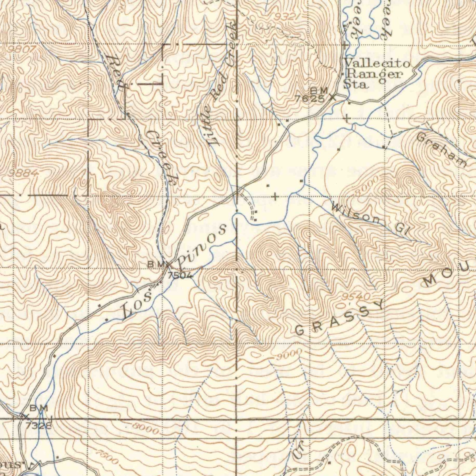
Read it closely and the valley resolves. A wagon road — the heavy double line — runs the length of the valley floor and crosses the river. Scattered along it, roughly a dozen individual buildings are drawn as solid black squares. None of them is named.
Exactly one named building appears in the whole reach the reservoir covers: Vallecito Ranger Sta, marked beside benchmark 7,625 feet. Full pool on the reservoir is 7,665 feet. The Forest Service ranger station in this valley stood about forty feet below the surface of the lake that replaced it.
- 7,625 ft at the ranger station
- 7,504 ft on the river below it
- 7,665 ft the lake at full pool
Further up Vallecito Creek, near Lake Eileen, the map labels a VALLECITO CLUB beside a benchmark of 7,727 feet — sixty-odd feet above the waterline, and so still dry today.
The creeks on the pre-dam map are the ones on the bridge photographs: Grimes Creek, Vallecito Creek, East Creek, Lion Creek, Bear and Little Bear Creeks, Red and Little Red Creeks, Weaselskin Creek. Graham Gulch is drawn on the east side — the same Graham name that appears in the 1903 land notices.
And here is the strongest thing the maps say, which they say by omission. No town, no school, no church, no cemetery and no post office is drawn anywhere in the Pine valley bottom. That is not the surveyors overlooking things: on the very same sheet, in the Florida River valley one drainage west, they label Little Red Sch and Columbus Sch. They mapped schoolhouses where schoolhouses stood. There was not one in the valley under the lake.
U.S. Geological Survey, Ignacio quadrangle, Colorado (La Plata County), 1:125,000 — edition of 1908, reprinted 1939 and the 1924 edition, both surveyed 1896, 1907 and 1924. USGS Historical Topographic Map Collection.
Five million board feet
Here is the part of the story nobody tells: before the valley was drowned, it was logged. On May 19, 1938, the Weston Lumber Company of Denver contracted with the government “for the purchase and removal of all saleable lumber from the Vallecito Reservoir site.” The company paid $9,500 for the timber of an entire valley floor.
By the end of 1939 the company had removed 2,500,000 board feet from 335 acres, about two-thirds of its contract, and 295 acres had been cleared completely of timber, brush and debris. The work shows up in the photographic record as weather: a caption dated August 15, 1938 notes that the haze in the frame is “smoke caused by clearing operations on left side of river.”
Bureau of Reclamation, The Pine River Project; Fort Lewis College Collection D 003, image D003061.
Two camps and a temporary town
Bids opened in Durango on December 15, 1937. The winner was the Martin Wunderlich Company of Jefferson City, Missouri, at $2,115,870. Construction began May 14, 1938, and for the next three years the valley held more people than it ever had as ranch country.
Two camps went up. The government's came first, in September 1937; the contractor's followed on May 13, 1938. The photographs catalogue them building by building — on the government side “permanent residence, office, and four temporary residences,” then rows of “two-room temporary residences”; on the contractor's side “2-room duplex residences built by Martin Wunderlich Co.” and “three large buildings… the commissary, mess hall and office.”
“View of government camp and contractor's camp from mountain on South side of valley. Contractor's camp to the left, government camp in center, and Vallecito Dam at extreme right.”
Caption, photograph D003001, A. F. Bateman, December 5, 1938
That one frame is the best picture anyone took of the valley floor as a lived-in place — and what it shows is not ranches. It is a company town with a dam at the end of it.
Bureau of Reclamation; Fort Lewis College Collection D 003, images D003001–D003005.
The road that had to move
Reclamation put the problem in one sentence: “The construction of Vallecito Dam would flood the road that ran through the valley. As a result, it was necessary to relocate the road.” The first stretch went to Martin Wunderlich on August 30, 1938 and was finished that December. The contract to complete the road around the reservoir went to the Wood, Morgan, and Burnett Construction Company of Durango for $14,592.66 — over 26,000 cubic yards of excavation, 16 culverts totalling more than 600 feet, and four bridges.
Those four bridges were photographed, finished, on November 15, 1940. They are named, dated, and located by survey station:
The four bridges, November 15, 1940
- Timber bridge over Grimes Creek, station 246+26 (D003422)
- Steel I-beam bridge over a branch of Vallecito Creek, station 250+60 (D003423)
- Steel truss bridge over a branch of Vallecito Creek, station 261+62 (D003424)
- Timber bridge over Middle Creek, station 269+30 (D003425)
And one detail worth carrying with you the next time you drive the lake: Reclamation records that “the steel I-beams and trusses were salvaged from an existing bridge that had to be dismantled for the road relocation.” Some of the steel in the new road came out of the old road — the one now under the water.
Bureau of Reclamation; Fort Lewis College Collection D 003, images D003422–D003425. See the Pine River Irrigation District finding aid.
Noon, April 21, 1940
The captions preserve the river's last years better than any narrative source. In November 1938 a photographer stood on the cofferdam and shot the channel downstream twice in a month, noting each time the sand deposits on both banks. In autumn 1938 the temporary log-crib drop was carrying “the full flow of the river which was estimated at 500 second feet.” The following May, at runoff, the same structure was measured again.
“Looking upstream at log-crib drop carrying the full flow of the river which was estimated at 1800 second feet.”Caption, photograph D003329, A. F. Bateman, May 9, 1939
Then a temporary cofferdam closed the channel on April 18, 1940, and at noon on April 21 water went through the outlet works for the first time. That is the hour the Pine River stopped running free down its own bed. The embankment topped out on July 25, 1941.
Fort Lewis College Collection D 003, images D003102, D003103, D003328, D003329; Pine River Irrigation District finding aid; Bureau of Reclamation.
A thousand people and a barbecue
Vallecito Dam was dedicated on September 14, 1941. Reclamation's account of the day is short enough to quote nearly whole, and it is the best paragraph in the federal record.
“Among those who spoke to the estimated 1,000 visitors as they enjoyed a barbecued beef dinner prepared by CCC enrolles, was Sinclar O. Harper, Chief Engineer of the Bureau of Reclamation, US Senators Alva Adams and Edwin C. Johnson, and Colorado Governor Ralph H. Carr.”
Bureau of Reclamation, The Pine River Project
Every speaker paid tribute to Edward T. Taylor, the congressman who had pushed the project through. The first water reached irrigators that same year, and the dam was formally operational in early 1942.
- 162 ft dam height
- 4,010 ft crest length
- 129,700 acre-feet capacity
- 2,720 acres at full pool
Sixteen years to fill
It is tempting to imagine the valley vanishing in a single spring. It did not. The dam was dedicated in 1941 and the reservoir kept rising, on and off, through drought years and wet ones, for the better part of two decades.
“in 1957, the reservoir was filled to its full capacity for the first time.”Bureau of Reclamation, The Pine River Project
Anyone who had lived or worked down there did not lose the place in a flood. They watched the water come up for sixteen years. If you want to see how far it has moved since, the lake level record runs from the first fill to this morning.
The same view, every year
The single best thing to survive from the valley is a photograph album. It belonged to Major C. A. Burns, a construction engineer on the project, and his grandson loaned it to Fort Lewis College's Center of Southwest Studies, which digitised 425 images made between 1938 and 1940 by four named photographers.
- 425 images, 1938–1940
- 189 by A. F. Bateman
- 84 by W. H. Foster
- 59 by B. T. Griffith
- 4 by A. R. Downing
What makes the album remarkable is not the individual pictures but the method. The engineers established numbered photographic points — fixed spots on the ground — and came back to them, year after year, to shoot the identical view. Point No. 2 sits on the right abutment about a quarter mile downstream of the dam. Point No. 5 is on the right side of the reservoir, 1,200 feet upstream of the axis. Every caption refers back to the frame before it.
Photographic Point No. 2, looking upstream — one view, six times
- June 16, 1938 — Bateman (D003006)
- October 24, 1938 — Bateman (D003007)
- July 12, 1939 — Griffith (D003008)
- November 30, 1939 — Bateman (D003009)
- July 2, 1940 — Bateman (D003010)
- September 14, 1940 — Foster (D003011)
Twenty-seven months, three photographers, one tripod position. Watch them in order and you are watching a valley close.
See the collection at the Center of Southwest StudiesCollection D 003, accession 2005:09015. The images are copyrighted by the Center of Southwest Studies and are not reproduced here — the captions quoted on this page are from the public finding aid. To request copies, contact [email protected] or 970-247-7126.
What the pictures don't show
You will read elsewhere that whole homesteads lie beneath Vallecito Lake, that a town is down there, that graves were moved. We went looking for all of it, and we want to be straight with you about what we found.
We read the captions of all 425 photographs and searched them for a school, a store, a town, a church, a cemetery, a ranch house, a homestead, a barn, a cabin. Not one appears. The pre-dam maps agree, and they name a schoolhouse in the next valley over to prove they would have named one here. Every building in the collection is either part of the dam or part of the two construction camps. The Bureau of Reclamation's project history mentions no houses in the basin, no relocated families, and no graves, and it states that “No condemnation proceedings were necessary.” The federal place-name database records no submerged feature here at all. Neither pre-dam topographic map labels a town, a school or a cemetery in the valley bottom between Bayfield and the head of the reservoir.
What the record supports is quieter. This was a thin scatter of ranches along a river, in a valley that never had a town and only intermittently had a post office. The one settlement that did have a store and a hotel and a hundred people stood four miles north of Bayfield — below the dam, and still dry. The valley that went under was pasture, timber, a wagon road and a river.
That is a smaller story than the legend. We think it is a better one, and it has the advantage of being true.
What we still can't answer
Several threads run straight into records that aren't online. We'd rather show you the gaps than paper over them.
- Whether anyone was forced out. Reclamation says all land was bought by agreement and “No condemnation proceedings were necessary.” Local accounts say a rancher named Dunsworth held out and was condemned. Those cannot both be right. La Plata County District Court records from 1938–39, or Reclamation's land files at the National Archives in Denver, would settle it.
- Who owned the drowned land. No federal source names a single landowner in the basin or gives an acreage or a price. The Pine River Irrigation District's records at Fort Lewis include a “certificate of ownership / schedule of lands” from about 1937 — very likely the parcel-by-parcel answer, on microfilm, unread.
- A lost place name. The pre-dam sheets carry a feature called “Old Fish Hatchery,” which appears in no modern database. We could not find it anywhere in the Pine valley reach, so it likely sits toward the Animas side. Where it stood, we don't know.
- Whether anyone died building it. No source we found mentions a construction fatality. That is not the same as none occurring, and we won't claim either way.
- How many came to the dedication. Reclamation counted about 1,000. A local account says 7,000. We use the sourced figure. A Durango paper from September 1941 would decide it, and those years exist only on microfilm.
And there is a voice we cannot reach. Fort Lewis ran a Vallecito Dam Oral History Project, and its finding aid still links a 77-minute interview with Jessie Wommer, recorded May 31, 1993 — the Wommers were among the families homesteading this valley from 1877. Both halves of that recording now return “file not found.” The tape is presumably safe in the collection; it is simply no longer on the open web. We have asked the archive for it.
Sources & notes
The backbone of this page is the Bureau of Reclamation's own project history — Wm. Joe Simonds, The Pine River Project (Reclamation History Program, 1994) — together with Reclamation's Pine River Project data pages. Archival detail comes from Fort Lewis College's Center of Southwest Studies: Collections M 103 and I 052 (Pine River Irrigation District records, 1930–1989), Collection D 003 (Vallecito Dam construction photographs, 425 images, 1938–1940) and Collection U 013 (Vallecito Dam Oral History Project). Newspaper material is from the Durango Semi-Weekly Herald via the Library of Congress's Chronicling America. Ute history is from the Southern Ute Indian Tribe and the Colorado Encyclopedia. Settlement history is from La Plata County's Pioneers, Prospectors and Trout (2010). Hatchery figures are from the Colorado State Game and Fish Commissioner's biennial reports, 1899/1900 through 1903/04. Post office dates are from Jim Forte Postal History. The pre-dam mapping is the U.S. Geological Survey's Ignacio quadrangle, 1:125,000, surveyed 1896, 1907 and 1924, in its 1939 reprint and its 1924 edition, from the USGS Historical Topographic Map Collection.
On quotations: newspaper passages were read from digitised optical character recognition and checked against the page images; photograph captions are quoted from the public finding aid. On photographs: the D 003 images are copyrighted by the Center of Southwest Studies (2007, accession 2005:09015) and are not shown here. If the Center grants permission, this page will carry them. The map detail above is different — it is a work of the U.S. Geological Survey and therefore in the public domain, reproduced here as a crop of the 1939 sheet.
Where sources disagree, we say so above rather than choosing quietly. A widely-shared account of this valley describes the dam as a “162-foot concrete wall”; it is a zoned earthfill embankment, and we have not relied on that source. Corrections and additions are welcome — this is a living community record. How to submit one.
Related: 85 years of lake levels · The Missionary Ridge Fire · Tuckerville, the gold camp that never paid · Fishing Vallecito