The Missionary Ridge Fire
In 2002 the worst wildfire in La Plata County's history burned for weeks, took 46 homes, and killed firefighter Alan Wyatt.
A valley primed to burn
The summer of 2002 arrived on the back of a historic drought. Colorado's spring snowpack came in around half of normal — roughly 53–55% — and it was gone by late May. La Plata County had recorded only about 1.31 inches of precipitation since January. Vallecito Reservoir was falling toward one of the lowest marks in its history, on its way to about 11% of capacity. The forest around the lake was as dry as anyone could remember. See how 2002 sits in 85 years of lake levels.
- ~73,000 acres burned
- 39 days to contain
- 2,000+ firefighters
- 1 life lost
The spark and the run
On the afternoon of June 9, 2002, around 2:30 p.m., a fire started at a switchback near the base of Missionary Ridge Road, off U.S. 550 at Hermosa north of Durango. A Forest Service investigator later concluded it was probably a carbon particle thrown from a vehicle's exhaust; the exact cause was never confirmed. In tinder-dry timber it ran almost at once — about 6,500 acres by nightfall on the first day.
“…that's pretty much when we knew we kind of lost the fire.”
Randy Baker, Durango Fire, on the first day
Over roughly five and a half weeks it grew to about 73,000 acres before crews reached containment in mid-July — sources record both July 15 and July 17. When it ended it was the second-largest wildfire in Colorado's recorded history; two decades on, after larger fires elsewhere, it ranked about seventh. More than 2,000 firefighters — some counts put it near 2,300 — came from at least four states, with a tent “fire camp” on the Durango High School fields and command at the county fairgrounds. It was the first deployment of the San Juan Hotshots and the first operating season of the Durango Air Tanker Base.
The fire that made its own weather
Nobody who fought it had seen fire behave the way this one did. Flames reached well over 250 feet and burned hot enough to consume aspen, which usually resists fire. The fire doubled back on itself, and at times the only choice was to pull back and let it run.
“Nobody had ever seen that kind of fire behavior before. Everything about it was just off the charts.”
Randy Black, then a volunteer firefighter, now a Durango Fire deputy chief
On June 17, 2002, as the fire pushed toward Vallecito, it generated its own weather: a rotating fire whirl — a “fire tornado” — touched down on the dry, drawn-down lakebed of Vallecito Reservoir, overturning and burning vehicles, campers, and boats left on the flats — flats that are the floor of the valley the reservoir covered. Atmospheric scientists at Colorado State and NOAA later studied footage of it, documenting a rotating wall-cloud structure and tree damage comparable to a strong tornado. That summer the reservoir never got even half full, bottoming near 11% of capacity — see 2002 in the lake's record.
Three hours to get out
For the families around the lake, the fire became a countdown. Crystal Schmit, a Vallecito-area resident, drove a school bus that ferried firefighters in and residents out, and remembers how fast the window to leave closed — from days, to hours.
“It doesn't ever really leave you.”
Crystal Schmit, Vallecito-area resident and school-bus driver
The Vallecito Community Wildfire Protection Plan later tallied the local toll: 28 structures lost at Vallecito and 28 at Durango.
Holding the line at the lake
As the fire reached the water, the newly formed San Juan Hotshots deployed for the first time, and the Durango Air Tanker Base ran its first operating season. The people directing the air attack understood what was at stake if the fire crossed.
“I remember calling the air attack, and I said, 'Give me every air tanker and every water dropping helicopter you have because we have to hold the fire here.'”
Shawna Legarza, San Juan Hotshots superintendent
“As we went down Missionary Ridge, I remember all I heard in my headset while we were flying was, 'Oh, my God. Oh, my God. Oh, my God.'”
Butch Knowlton, La Plata County emergency management
In memory of Alan Wyatt
July 2, 2002 · the one life lost to the Missionary Ridge Fire
Alan Wayne Wyatt was 51 years old, a professional timber faller from Durkee, Oregon. Born in Sacramento in 1950, he spent nearly three decades felling timber across the western states and Alaska, and for about ten summers he brought that skill to wildfire crews — the sawyers who drop dangerous, fire-weakened trees so other firefighters can work safely.
He was more than his trade. He and his wife, Vikki — married 32 years — ran a cattle operation, Wyatt Livestock, with their son. He rode saddle broncs and judged rodeos, worked leather and saddles by hand, played guitar, and served as a lay preacher. He left Vikki, his daughter Leigh Ann and son Wells, and two granddaughters.
On July 2, 2002, on the east side of the fire near Middle Mountain, Wyatt was cutting a marked hazard tree when a separate fire-weakened tree — a green aspen whose roots had burned away — fell and struck him. He died of blunt-force injuries.
Alan Wyatt is honored at the National Fallen Firefighters Memorial in Emmitsburg, Maryland (2003), on the Oregon Fallen Firefighters Memorial, and by the Wildland Firefighter Foundation. Closest to home, he is remembered at Vallecito by Carving 5 on the Tour of Carvings — a sculpture, near the community center, of a firefighter holding his helmet to his heart.
His tribute at the National Fallen Firefighters MemorialWhen the rain became the enemy
Containment in July was not the end of it. The fire left about a third of the burn at high severity and another third at moderate — bare, water-repellent soil on slopes from roughly 6,500 to 11,400 feet. When the summer monsoon arrived, ordinary thunderstorms turned those drainages into channels for mud, ash, and boulders. The reckoning that followed was written creek by creek, week by week.
- 31% high severity
- 30% moderate
- 39% low / unburned
Burn-severity split: USGS Open-File Report 2007-1289 (p. 2).
The dated reckoning
The U.S. Geological Survey documented the summer's debris flows storm by storm. Around Vallecito, County Road 501 was buried again and again.
- July 11
The first storm — a thunderstorm south of the Vallecito dam. CR 501 and the softball field flooded with ash and mud.
- July 22
Ash and mud reached the reservoir; CR 501 closed from the dam to CR 240. A 400-pound boulder came down; Red Creek flooded.
- July 23 — the big one
The season's only storm with even a ~10-year recurrence. Debris flows ran below Lemon Reservoir on Dry, Shearer, and True Creeks; at least five vehicles — four of them occupied — were swept off CR 240; deposits reached four feet deep with rock clasts to three feet across. Floods crossed CR 501 along the reservoir.
- August 3–29
Repeated flows near the lake through the month. Freeman Creek and Root Creek ran again and again — Root Creek left deposits about ten feet deep and six-foot boulders at the CR 501 junction on August 3.
- September 7
A Stevens Creek flow buried a home more than 200 feet from the channel in tons of rock and mud, with eight-foot boulders; Coon Creek and the Freed and Woodard canyons also ran.
- September 10–12
The longest storm of the summer. Coon and Stevens Creeks, and Root Creek near Vallecito; CR 501 closed at Jack and Dry Creeks near the reservoir.
- September 20 & October 2
The final, diminishing events of a four-month siege.
Chronology: USGS Open-File Report 2007-1289 (pp. 10–11).
The quiet violence of ordinary rain
The most unsettling finding in the USGS study is how little rain it took. Strip a steep slope of its cover and even a common cloudburst becomes a battering ram.
Most of the debris-flow and flood-triggering storms had recurrences of less than two years — ordinary rain, extraordinary damage.U.S. Geological Survey, Open-File Report 2007-1289
“All of a sudden, we heard a rumble and we saw a boulder about the size of a Volkswagen coming down the stream aiming right at us…”
Peter Glick, Falls Creek
Putting the mountain back
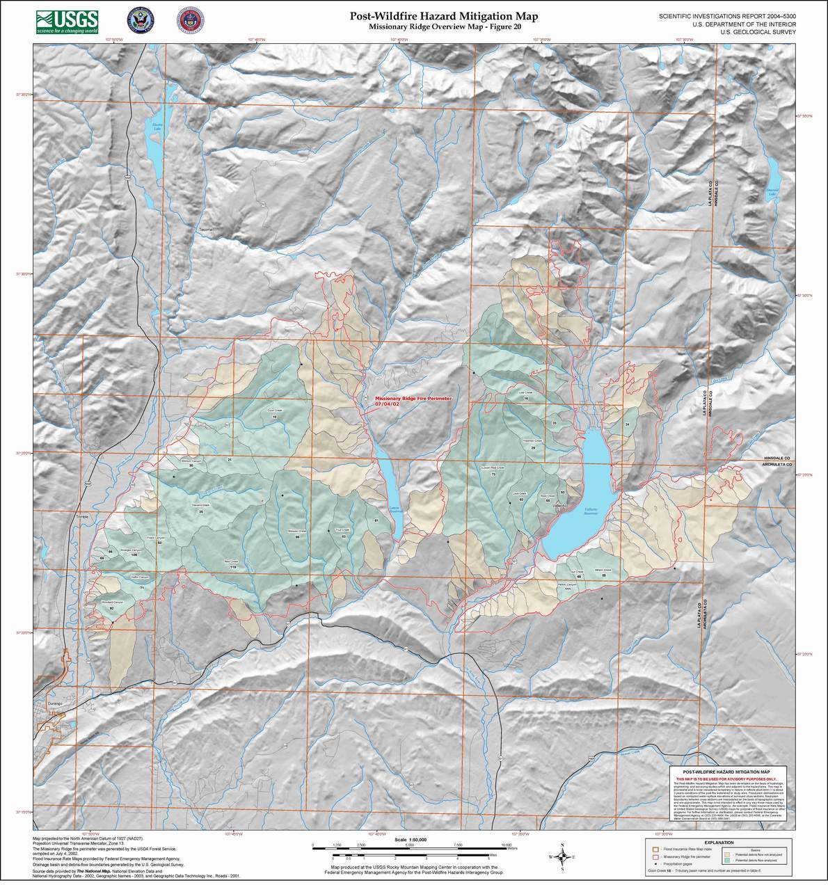
Federal Burned Area Emergency Response (BAER) crews raced the monsoon. Of the fire's roughly 73,000 acres, about 23,000 — a third — were recommended for treatment.
Near Lemon Dam the work went well past the textbook: 231 acres got log erosion barriers at 90–250 per acre where 40 is typical, and crews hand-spread and crimped straw mulch across more than 250 acres, seeding at 60–75 pounds an acre against a usual 40, plus check dams and debris racks.
To get ahead of the floods, the USGS installed a network of telemetered rain gauges over the burn in just over two weeks, feeding real-time flash-flood warnings to forecasters and county responders — one of the early rapid-warning networks of its kind. That instinct — watch the sky over a scarred watershed and sound the alarm early — is exactly what mattered again twenty-three years later, when dawn gauge alarms gave the valley its warning in the October 2025 flood.
BAER figures: USGS Open-File Report 2007-1289 (pp. 2, 33–39). Rain-gauge network: USGS Fact Sheet FS-036-03.
How the valley healed
Recovery began almost at once — aspen first, sending up shoots from surviving roots, with conifers following slowly behind. Fort Lewis College and the San Juan National Forest replanted and have tracked the comeback across roughly 840 study plots in the years since. The fire also gave rise to the region's grassroots fire-preparedness movement, today's Wildfire Adapted Partnership and Firewise community.
And in the most Vallecito way of all, neighbors turned grief into something you can stand in front of. From the trunks of fire-killed trees around the lake, artist Chad Haspels carved the Tour of Carvings — sculptures honoring the firefighters, first responders, animals, and the valley's rebirth, each topped with a carved flame for 2002. Carving 5 is Alan Wyatt's.
Explore the Tour of Carvings“All that was left of our house at the end was some concrete and a chimney…”
William Herringer, East Animas
What we still can't fully answer
This is a living community record, and honesty means marking its edges. A few things we could not source to our satisfaction, and have left out rather than guess:
- The fishery. The debris flows choked Vallecito's tributaries with sediment, and mercury and other toxins spiked — but we found no citable record of a kokanee die-off or a restocking program, so we don't claim one. (The lake's mercury advisory for walleye and northern pike is a separate, long-standing issue.)
- Lost storage. There is no published survey of how much reservoir capacity the sediment cost, so we state no number.
- The exact toll. Sources disagree on the details — containment on July 15 or July 17; “83 structures” counting outbuildings versus 46–47 homes and cabins (about 56 homes only if the separate Valley Fire is counted with it); suppression costs quoted from about $37 million to $40 million. We show the range rather than pick a favorite.
If you have a verifiable source that fills one of these gaps, we'd like to hear it
Sources & notes
Primary sources include the U.S. Geological Survey (Open-File Report 2007-1289 and Fact Sheet FS-036-03), NASA Earth Observatory, NOAA/CIRA at Colorado State University, History Colorado's Colorado Encyclopedia, the Durango Herald's 20-year retrospective (Aedan Hannon, June 18, 2022), the National Fallen Firefighters Foundation, the Wildland Firefighter Foundation, Oregon DPSST, and the Vallecito Community Wildfire Protection Plan (Upper Pine River Fire Protection District). Two books tell the story at length: Bob Thompson, Fire Story — Vallecito Burning (2004), and Jim Greenhill, Fire in the Sky (Durango Herald Small Press, 2002).
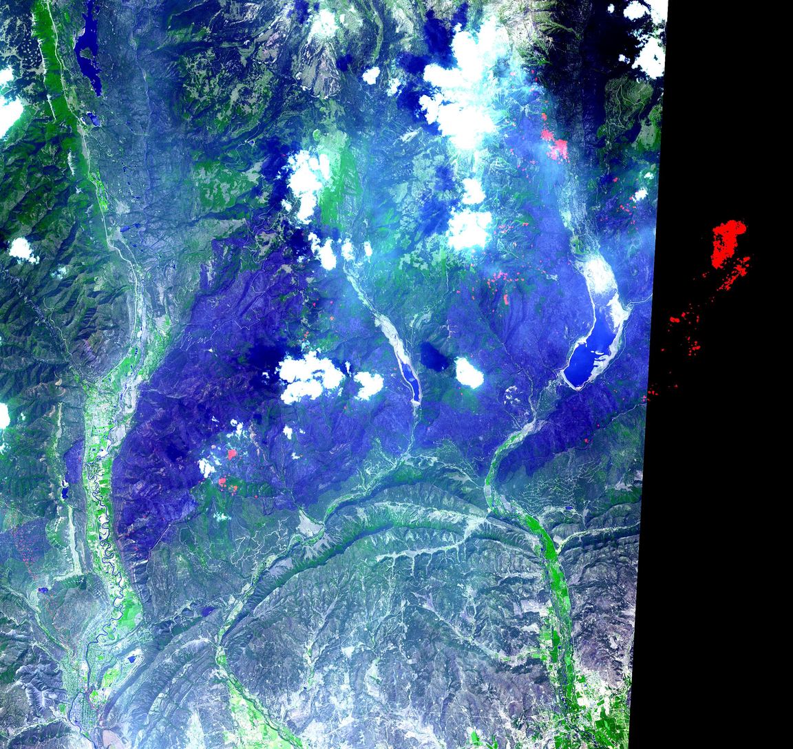
Photos: the satellite burn-scar (NASA/ASTER) and the burn-perimeter map (USGS) are public-domain works, credited in each caption. Press and eyewitness photographs of the fire — including the fire-whirl footage, which comes from a private video — and photographs of Alan Wyatt are copyrighted by their owners and are not shown here. If you hold rights to a Missionary Ridge photo and would like to share it, please get in touch.
Corrections and additions are welcome — this is a living community record. How to suggest a correction